The mysterious disappearance of Cedar Swamp & Sandhill
by Carl Vest

As South Hill continues to increase in population and the landscape is changed by development, past identifiers and terminology begin to fade from conversations, records, and memories. So it is with two locations once commonly known as Cedar Swamp and Sand Hill. Never heard of these places? Not surprising, unless you grew up on the Hill or have lived there most of your life.
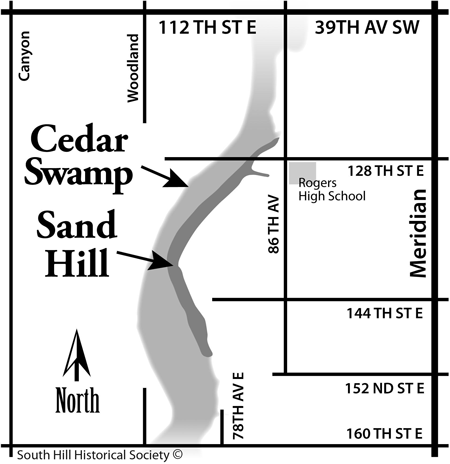
The dimensions of Cedar Swamp are difficult to delineate. Geographically it’s a large area, length-wise about four miles long and generally oriented north and south. The width varies depending on where measurements are made. It’s located on the western side of South Hill, between Meridian Avenue and Canyon Road. And, it must be noted that Cedar Swamp, having been generally drained, no longer looks like a swamp.
To get an idea of its location imagine driving your automobile west, from Meridian, on 160th Street, toward Canyon Road. At first you’re on generally level ground, but after passing by 78th Avenue you start down a rather steep hill. The downhill grade continues for about one-quarter mile and you then ascend an equally steep hill eventually intersecting Woodland Avenue. You have just crossed through Cedar Swamp near its southern end. Or, take a drive on 128th Street. Starting at Rogers High School, and traveling west, you immediately encounter a very steep downgrade. It also has a length of about one-quarter mile. Continuing on, you enter an upgrade that takes you out of the dip and to the top of a hill. You have now crossed Cedar Swamp near its northern end. And if you search for a crossing between 128th Street and 160th Street you will find that there are none.
To the early settlers this was a formidable east-west obstacle. Unlike today, there were very few homes in the hollow and no roads. Wild animals abounded, including bear and coyotes. It was a collection point for water runoff from the higher hills on both sides. At one time it had been heavily wooded but was logged off early. Dorothy Norris (Swalander), who grew up in the 1930s, living next to the swamp, remembers her father using it to pasture dairy cattle. The family generated some cash by selling cream. The raw milk was fed to the farm’s calves and pigs. Bonnie Starkel (Nicolet) also grew up near the swamp and recalls that at one time her husband Dave Starkel, and others, herded cattle on horseback into the swamp.
So if this is Cedar Swamp, where is Sand Hill? Anyone who has tried to dig a hole on South Hill knows that the soil is primarily glacial till, that is, mostly rocks. But it turns out that the retreating glacier that formed South Hill left numerous deposits of sand along the eastern slopes of Cedar Swamp. So from a little north of Rogers High School to about where the electric transmission lines cross Cedar Swamp there are many deposits of sand. The early settlers called this area Sand Hill.
Carl Vest, PhD, is a founding member and Research Director for the South Hill Historical Society.